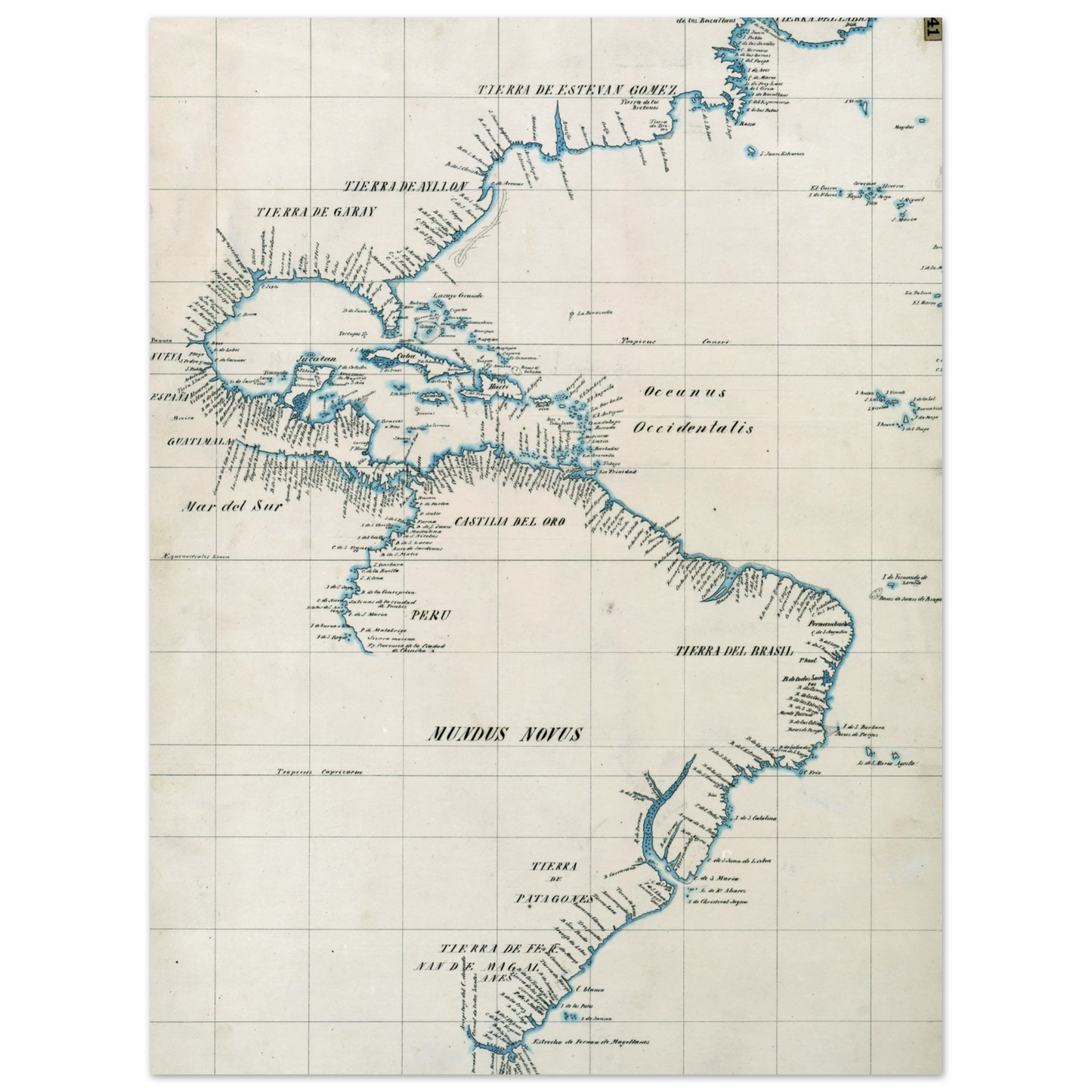
The Padrón Real (Royal Register) was the official and secret Spanish master map used as a template for the maps present on all Spanish ships during the 16th century. It was kept in Seville, Spain by the Casa de Contratación. Ship pilots were required to use a copy of the official government chart, or risk the penalty of a 50 doblas fine. The map probably included a large-scale chart that hung on the wall of the old Alcázar of Seville. Well-known official cartographers and pilots who contributed to and used the map included Amerigo Vespucci, Diogo Ribeiro, Sebastian Cabot, Alonzo de Santa Cruz, and Juan Lopez de Velasco.
Estêvão Gomes (c. 1483 – 1538), also known by the Spanish version of his name Esteban Gómez, was a Portuguese explorer. He sailed in the service of Castile (Spain) in the fleet of Ferdinand Magellan, but deserted the expedition when they had reached the Strait of Magellan and returned to Spain in May 1521. In 1524, he explored the coast of present-day New England and Nova Scotia. As a result of Gomes' expedition, cartographer Diogo Ribeiro was the first to accurately portray North America with a continuous coastline stretching from Florida to Nova Scotia.
Magellan expedition
In 1519, Gomes sailed with the Magellan expedition as the pilot major of the fleet aboard the San Antonio. His real ambition, however, was to become captain of the ship. Gomes frustration grew when he was passed over for promotion in favor of Magellan's inexperienced nephew, Alvaro de Mesquita. Near the Strait of Magellan, Gomes overpowered Mesquita, took control of the San Antonio and sailed back to Spain in May 1521. Upon their return, Gomes claimed his mutiny was justified by Magellan's abuses and poor management. The mutineers were thrown in jail while their claims were investigated, but within six months all except Mesquita were freed.
North American coast
In 1523 Gomes received authorization from the Spanish Crown to search along the North American coast for an alternate passage to Asia that would be quicker and easier than the Strait of Magellan. A 50-ton caravel, La Annunciada, was built for the purpose and set sail from Corunna on 24 September 1524 with a crew of 29 men.
No eyewitness accounts of this expedition have survived. Knowledge of the voyage comes from brief second-hand summaries by contemporary historians Oviedo, Peter Martyr, and Alonzo de Santa Cruz, as well as cartographic information captured by Diogo Ribeiro.[5] Even the general direction they sailed has been disputed. For a long time, it was assumed that Gomes explored the American coast from north to south. More recently, a good case has been made that he started from the Spanish Caribbean and sailed north.[4]
If Gomes proceeded from south to north along the coast, it is likely that he stopped first at Santiago de Cuba to load fresh supplies. From there, the explorers followed the coast from Florida to Labrador, making their most careful survey along the shores of what would become New England. Gomes sailed up the Penobscot River to the future site of Bangor, Maine, naming the waterway "El Rio de Las Gamas". He named other significant landmarks such as "Rio de San Antonio" (now the Merrimack River) and "Cabo de las Arenas" (present-day Cape Cod).
While exploring the area of Penobscot, Gomes abducted at least 58 natives and took them back to Spain as evidence of a potentially lucrative slave trade. When he reached Spain in August 1525, Gomes sent word to the king of his return. Peter Martyr claimed that when the message reached court, the word for slaves (esclavos) had been misunderstood to mean cloves (clavos), creating for a moment the false impression that Gomes had found a route to the Orient. When the mistake was cleared up, Charles was upset that the injunction against enslaving American natives had been ignored and ordered them to be freed.
As a result of Gomes' expedition, cartographer Diogo Ribeiro's 1525 Castiglione map was the first to accurately portray North America with a continuous coastline stretching from Florida to Nova Scotia.[4] Ribeiro labeled the region of present-day New England as the "Land of Estêvão Gomes" (Tierra de Esteban Gómez).
Our Master's Edition archival paper, in off-white and uncoated, offers museum-quality for art enthusiasts seeking a luxurious way to enjoy world-class artworks:
No minimum orders, printed and shipped on demand.